Okay, let's start by addressing the giant elephant in the room; it's been an inexcusably long time since I've updated this blog. (I'm not talking about a matter of a few weeks. I didn't post at all in 2013.)
I think the main issue is that I didn't think that I had anything particularly interesting to post. Life overseas in Japan, on a beautiful semi-tropical island, had become a bit mundane. You live anywhere for an extended period of time, and I think you start to take everything for granted.
It took a trip back to the United States in December to make me realize just how special Okinawa is. (Sorry, no offense to my family back home. The vacation was lovely, and the company was amazing, but it was COLD.)
 |
| Cold enough for Dad and me to be wearing coats on a train. Thanks, Illinois. |
I came back to Okinawa with a renewed sense of wonderment. Everything seemed new and exciting and different again. It's my goal to maintain that feeling of curiosity and awe for the remaining year and a half on the island. Sometimes I need to stop and remind myself to look at everything through fresh eyes.
Mt. Furushi Hike
Loren and I stumbled across a new hike yesterday to Furushi-Dake (Mt. Furushi). It's one of three mountains clustered on the Motobu Peninsula, just north of Nago City. The route takes roughly 2-3 hours to complete. Loren and I stopped to eat lunch and take photos, so it may take you less time.
Directions: To get to the hike, travel north on Highway 58 past Nago. Make a left turn onto Highway 449, toward Motobu-Town. After about ten minutes of travel, you'll see a sign that says "Entrance to Mt. Katsuu." Turn right at the sign and follow the road until you come across a small community center on your left. Park in the parking lot in back.
Across from the community center is a small road leading downhill to an orange grove. Follow the road past several houses and barns.
 |
| Mt. Furushi in the distance. Note the exposed rock face on the mountain. It's one of the highlights of the hike. |
 |
| Abandoned motorbike |
 |
| One of the farm buildings. This one housed a ridiculously loud goat. |
After you've walked about half a mile, you'll see a sign on your right. This is the trail head.
 |
| Note: This is also the trail head for the Awa-Dake hike. I'm hoping to explore it next weekend, so expect an upcoming post. |
You'll walk for about half a mile through an orange grove. While we didn't eat any of the mikans along the path, the route was littered with the little tangerines' peels. Someone (either the farmers, other hikers or animals) clearly enjoyed them.

The pathway juts off into smaller routes used by local farmers. Follow the main path until you reach a metal pole with a soda can on top of it and a small sign in kanji. This indicates the beginning of the actual hiking trail.
 |
| Oh, Okinawan landmarks ... |
 |
| The hike is home to the usual Okinawan flora and fauna, including spiders as big as your hand. |
After about a quarter mile, the trail will fork in two. The pathway to the left will take you on a five-hour hike to Awa-Dake. I've heard that the Awa-Dake hike is fairly long and strenuous, so don't accidentally take it. The fork on the right heads uphill and will lead you to Furushi-Dake.

From here, the hike runs mainly through the jungle. The brush wasn't too bad in the winter time, but I imagine that it can get a little unruly during the spring and summer. Expect to climb across sharp coral boulders along the way.
The view, however, makes up for any difficulties encountered on the hike. Along the way, you'll have a clear panorama of the south-eastern Motobu peninsula and Ie-Jima.

 |
| Loren took over the photography from here |
 |
| Sign pointing to the summit |
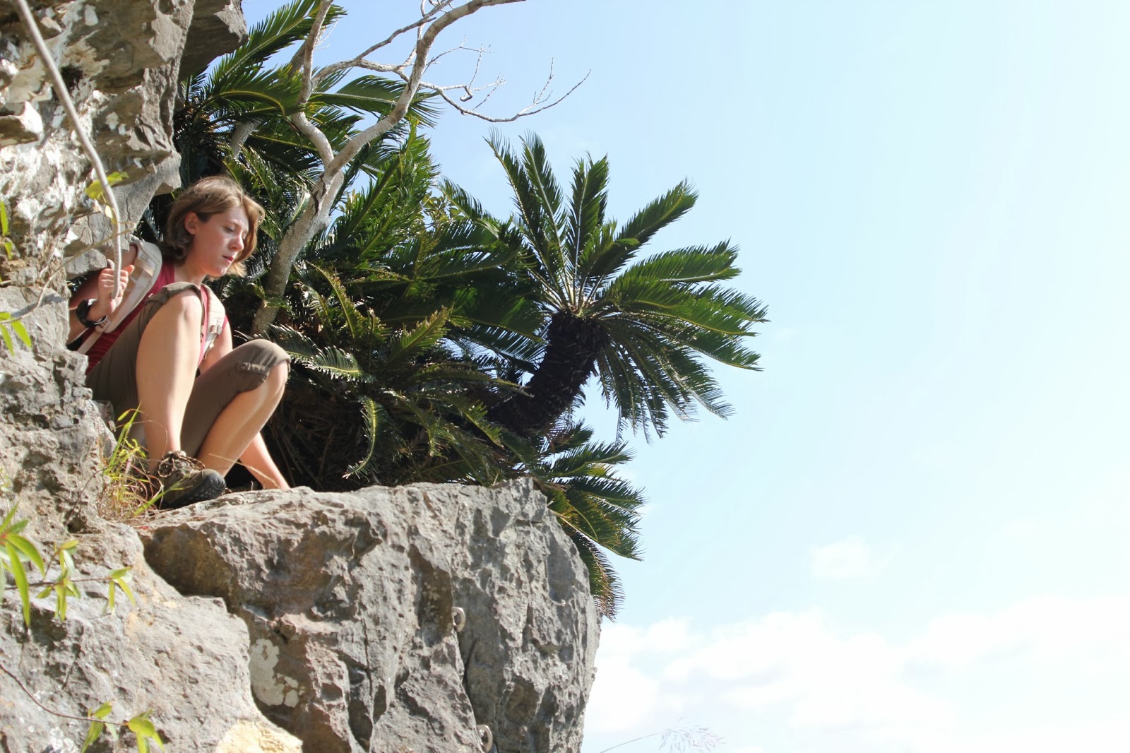
Closer to the top, you'll encounter two signs with arrows. The sign on the left will direct you toward the summit. The right sign indicates the trail to the rock face. This sheer cliff is the defining characteristic of Mt. Furushi. Most Okinawan mountains are slightly rolling and covered fully in jungle. There aren't very many exposed rock cliffs.
While the view is amazing, take caution hiking along the edge of the mountain. I definitely don't recommend it for kids 10 and under.
You'll start by traveling along a narrow edge. You may need to crouch down on your hands and knees to squeeze under the first ledge.
 |
| You can't see it in this photo, but the mountain drops off suddenly on my left. |
As you inch along the cliff, you'll hold onto a rope for support. During some parts of the hike, the rope will be the only thing keeping you from falling hundreds of feet down the mountain. Again, be careful along this section.
 |
| View from the rock face |

There's a very narrow ledge where you'll have to climb up the rock. While this isn't too scary climbing up it, going back down is slightly terrifying. Just hold onto the rope and be careful where you're going. I recommend the tried and true Karis-method: sitting on your butt and scooting along.
 |
| The expression on my face is priceless. |
After you've gotten your kicks climbing along the rock face, take the left trail up to the summit. It's probably about a half-mile hike from where the trail forks.
Once you reach the top, there's a flat area where you can picnic. (I brought a chicken-and-rice bento box from Family Mart, and Loren had a taco rice hand-roll.)
 |
| Really roughing it. |
 |
| Panorama of the top of the mountain. |
As we were packing up our lunch, a Japanese couple came along. They took our photo for us and we chatted a bit. They'd spent New Year's in Miami and were excited to share their experiences.
 |
| Atop Mt. Furushi |
Overall, the hike was about four miles long. It took approximately two hours to complete. (I used my new Garmin watch to time everything, but I forgot to turn if off on the drive home, so the hike appears SUPER long. Noob.)
This was one of the better-maintained hikes that I've experienced in Okinawa. Most of the brush was trimmed back, and the trail was well-marked with pink plastic ties.
 |
| Back through the orange grove |
 |
| The path to Mt. Furushi winds up the right hill. |
 |
| A goat pen on stilts |
Once we got back to the parking area, I purchased a bag of oranges from the community center. (I felt bad about everyone else eating their oranges.) These mikans are small and slightly sour, but I think that may be because of the season. The normal mikan-picking time is around the spring, if I remember correctly. Still, they aren't bad for a winter fruit.
 |
| 200 yen for a bag of about 20 little oranges |
If you're planning to hike Furushi-Dake, I strongly recommend checking out this website. He's mapped out the entire route in great detail.
Stay tuned for another blog post this weekend. Mata ne! See you soon!
No comments:
Post a Comment